Lullington in East Sussex lies on top of the Downs about 2 miles from and overlooking the
busy A27 Eastbourne to Lewes road, you can drive through it by passing by
the Long Man of Wilmington .
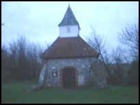
The church was probably originally built in the 1180's, and just consisted
of a chapel. It was probably founded as a retreat for the monks of Alciston
but was handed to the Monastry in Battle Abbey for a time. The height of the
village provided cleaner drier air than the surrounding valleys and was more
isolated making it more suitable for the monks meditations.
The church was transferred to Richard de la Wych the Bishop of Chichester
in 1251, who transfered it to the Dean and Chapter of Chichester, who added
to the church in 1340.
It is believed that the village was badly effected by the Black Death and
the remaining population moved to Lullington Farm, this explains why there
are so few buildings near the church.
During the early 1500's records show that the church had a number of
bequests associated with it, implying that the area had a number of
rich patrons, who also extended and added to the church.
The local legends believe that the majority of the church was destroyed
by the troops of Oliver Cromwell in the 1650's.
Nowadays the church only consists of part of the chancel of the much larger
older building. The village itself only consists of two houses and the church.
It is best reached by walking up the hill from Alfriston .
Views
Lullington in East Sussex has beautiful views all round with the white chalk dotted fields
and grazing sheep providing quiet and scenic views, and in the valley lies
the river Cuckmere near Alfriston .
To the north lies the marsh lands before the land rises to where the
Forest of Andredsweald used to start near Chalvington .
Services
Lullington in East Sussex has no services or shops and only two houses left next to
the church.
The nearest village is Alfriston with its tourist services about 1 mile
to the West.
The nearest major shops and train services are in Lewes about 6 miles west.
Map
Lullington is shown as the red symbol on the map.
Nearby Villages (click on symbol to see the village page)


 Lullington in East Sussex lies on top of the Downs about 2 miles from and overlooking the
busy A27 Eastbourne to Lewes road, you can drive through it by passing by
the Long Man of
Lullington in East Sussex lies on top of the Downs about 2 miles from and overlooking the
busy A27 Eastbourne to Lewes road, you can drive through it by passing by
the Long Man of 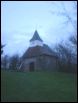 Lullington in East Sussex has beautiful views all round with the white chalk dotted fields
and grazing sheep providing quiet and scenic views, and in the valley lies
the river Cuckmere near
Lullington in East Sussex has beautiful views all round with the white chalk dotted fields
and grazing sheep providing quiet and scenic views, and in the valley lies
the river Cuckmere near 


